Using LLMs to steer a sailboat
Can an off-the-shelf multimodal language model sail a boat around an island, just from a camera image, a chart and a sentence of instructions? I tried it in my simulator. The short answer: somewhat.
Why I tried this
My long-term goal is a sailboat you can talk to: “round the orange buoys twice, then pass between the yellow ones”. Robotics research calls models that turn camera images and language into actions vision-language-action models (VLAs), and training one is a serious project. Before starting it, I wanted a cheap baseline: what happens if I simply give a large multimodal model — Claude, via its API — what the boat sees and ask it where to steer?
The setup
Everything runs in my simulator: a MuJoCo model of a small sailboat with sail and rudder physics, the same ROS 2 heading controller as in my autonomous navigation stack, and maps of real waters. The tests here use the Landgraben, a pond with a large island in the middle (scaled to twice its real size), with six coloured buoys and the wind blowing from the south.
Every two seconds of simulated time, the model gets:
- the onboard camera image, with a bearing scale along the top (degrees off the bow) and distance marks on the sides (where the water is 5, 10, 20 and 50 m away),
- a chart, north up: land, buoys, the boat and the track it has sailed, a scale bar, the no-go zone into the wind and a yellow line showing where the current course leads,
- instruments in text: heading, speed, wind, the range of headings that cannot be sailed, and the point of sail,
- the task in plain English, its own last few decisions, and a running progress note it wrote itself.
It answers with a short observation, an estimate of how far the nearest land ahead is, a course change in degrees, and whether the task is done. My autopilot then holds that course until the next decision. The simulation waits while the model thinks, so slow and fast models are compared fairly.
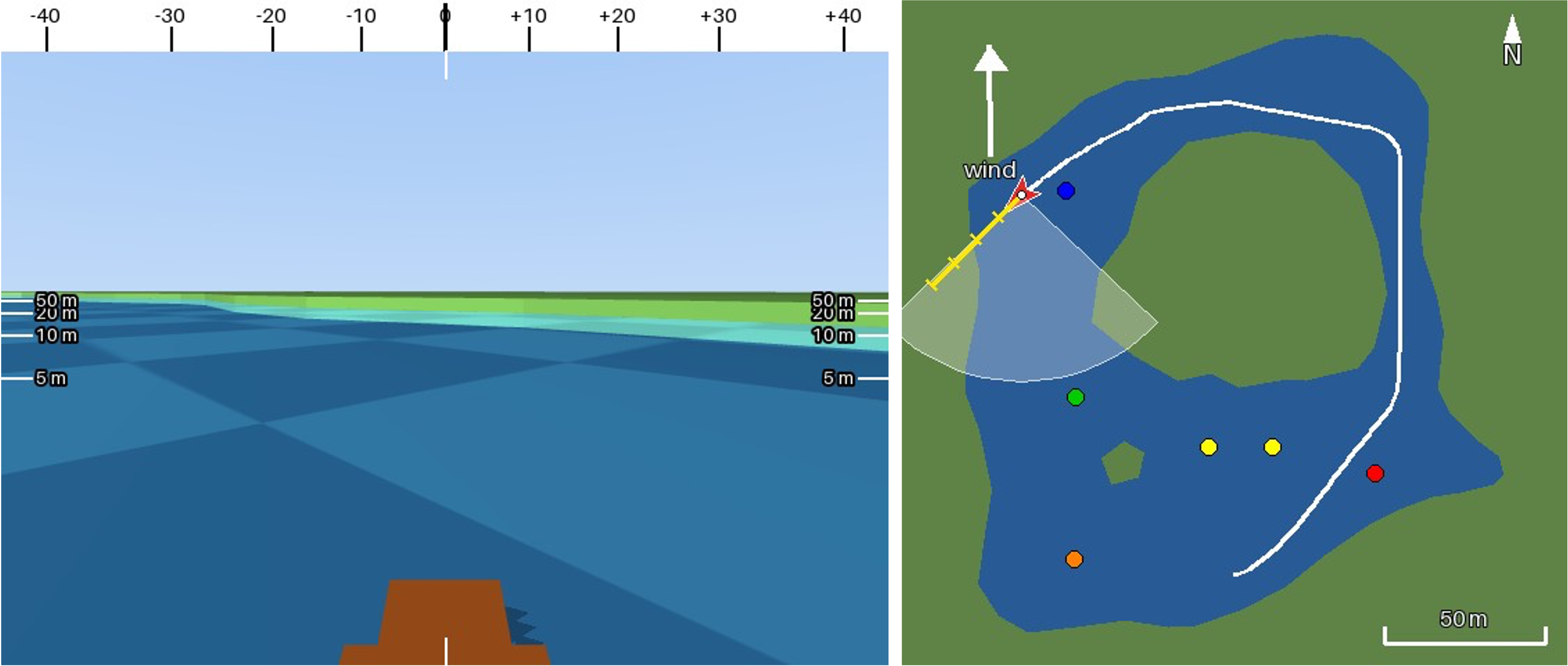 The model’s input at one decision. Its answer: “Open water ahead, but the outer west shore is now about 20 m off along my 225° course (camera and chart agree), so it is time to tack.”
First steps: sail to a buoy
I started small, with Claude Haiku 5.5, the smallest and cheapest model. “Sail to the orange buoy” failed at first in an instructive way: the boat’s own bow, which is brown-orange and always visible at the bottom of the image, was taken for the buoy and the model held course, “buoy dead ahead”, straight into the bank. And when the buoy was behind the boat, it steered towards whatever buoy it could see instead of looking around.
Two sentences in the prompt fixed both (“the brown shape at the bottom is your own bow”; “if the target is not in view, turn to look around”). After that Haiku searched methodically, named every buoy it passed with bearings accurate to a few degrees, and reached its targets reliably in about half a minute, for a fraction of a cent per run.
Claude Haiku 5.5: “Sail to the green buoy.” It finds the buoy, steers around the fountain island and reaches it after 57 seconds. 29 decisions, 1.7 s each on average, cost: less than one cent. (Video at 2× speed; the inset shows the onboard camera.)
The real test: around the island
Then the task I actually care about, one sentence with several steps:
Drive around the big island, start on the side with the red buoy and follow the shore on your right side so that you are between the shore and the island, pass the blue buoy, then pass the green buoy and end between the yellow buoys.
This needs everything at once: understanding the instruction, keeping track of progress over several minutes, reading the shore, and sailing upwind — which means tacking, because a sailboat cannot point closer than about 45° to the wind.
It took many attempts. The failures fell into a few groups:
Judging distance to land. The banks are low and green; at 5 m and at 50 m they look much the same. I logged the true distance next to the model’s own estimate: in one run, land 10–20 m ahead was rated “over 50 m” in 16 of 17 decisions, and land 20–50 m ahead was rated “over 50 m” or “no land” in 40 of 47. Up close the estimates were good — but by then it is too late to turn.
Spatial reasoning. The model sees the world from the boat: left, right, ahead. Many instructions are about the map: north, south, behind. Translating between the two went wrong in three ways:
- Through the island. The island is low, so buoys on its far side are visible over the land. Models steered straight at them, as if the island were not there.
- Which side. In one run I asked for the green buoy to be passed on its south side. The boat sailed south-east with the buoy on its right, which puts the boat north of the buoy. The model still noted “passed on its south side”.
- When something is passed. “Abeam” means level with the boat, 90° to the side. The model called a buoy 25° off the bow “nearly abeam” and declared the task done, while the finish gate was still 9 m ahead.
The north-up chart would have answered all three questions at a glance, but the models mostly reasoned from the camera image. My guess is that this is because the answer itself is egocentric because a turn in degrees off the bow can be read almost directly from the camera’s bearing scale, while the chart first needs a mental rotation from north-up to the boat’s heading. Testing that, with a chart-only pilot or a heading-up chart, is the next experiment.
Sailing. The models know the rules, e.g. “the wind blocks a left turn here”, “I must tack”, but executing them was another matter: switching tacks every two seconds, or turning back halfway through a tack, stops a sailboat dead.
What made the difference
Almost every improvement came from changing what the model sees and what it has to do itself, not from cleverer wording:
| Problem | What I changed |
|---|---|
| Wrong arithmetic between relative and true wind | The instruments state the true wind, the no-go zone as a range of headings, and the point of sail |
| Asking for headings into the wind | The autopilot never steers into the no-go zone; it sails close-hauled at its edge and tells the model |
| Tacks reversed halfway | The model decides when to tack; the autopilot carries the tack out and asks again once the boat is moving |
| Land misjudged at medium range | Distance marks in the camera image, and a course line on the chart that shows when a course hits land |
| Losing track of a multi-step task | A progress note the model writes each time and reads at the next decision |
| Ambiguous instructions | More explicit wording: “to the north”, “from east to west” |
The common thread: compute what can be computed, and let the model decide rather than calculate. That is also the split I plan for a trained system with a language model for the plan and proper control underneath.
A full lap
With these changes, Claude Opus 5.5 sailed the whole course: red buoy first, north through the narrow east channel, west past the blue buoy, three tacks down the west channel, past the green buoy and through the gate between the yellow buoys without touching land.
Claude Opus 5.5 completes the course in 290 seconds of sailing (video at 4× speed). 123 decisions; the onboard camera is in the bottom right, the chart in the bottom left.
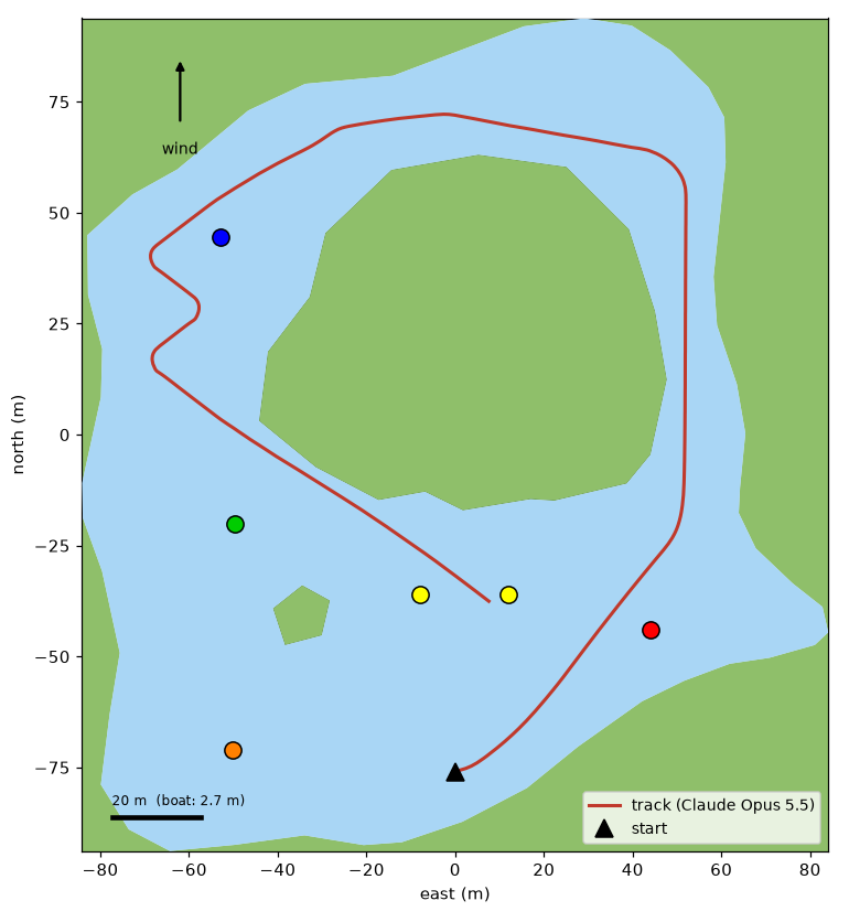
Its progress notes read like a navigator’s log. It even worked out a coordinate system from the chart’s scale bar (“The boat is at about chart (358,150), running north up the east channel on heading 1°. Scale: about 2.3 px per metre.”). Its plan at the start:
Start, decision 1: heading toward the red buoy (about 54°) to begin the east side. The route is counter-clockwise: red buoy (east), then north up the east channel, then west across the north, then south past the blue buoy and on to the green buoy. Finish between the yellow buoys (centre south). Keep the outer shore on the right and the island on the left. Wind is from the south.
Claude Sonnet 5.5 came close in several runs with the full lap in the right order, stopping just short of the finish gate, at less than half the price.
Models, speed and cost
| Model | Time per decision | Typical cost | In my tests |
|---|---|---|---|
| Claude Haiku 5.5 | 1.5–5 s | cents per run | reliable for single targets; misjudges land in narrow water |
| Claude Sonnet 5.5 | 2–3 s | $1.40–2.50 per lap | nearly completes the course |
| Claude Opus 5.5 | about 8 s | $2.50–3.60 per lap | completed the full course |
So — can an LLM sail?
Somewhat. A model like this reaches goals and plans sensibly at a coarse level. Its notes are often better than its steering. Stronger models do clearly better. But it only works with carefully designed inputs, and long tasks fail on a single lapse — one misjudged shore at the wrong moment. My results are also based on a handful of runs per variant, so they show tendencies, not success rates.
The simulator and the LLM pilot are on GitHub: CptK/sailboat-simulator.